

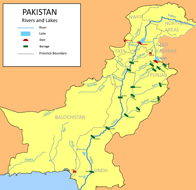
Rivers of Pakistan
Rivers have a unique and alluring quality about them. It’s as if they hypnotize you once you get to look deep into their water. The soothing sound of this flowing water is calming, allowing you to forget about your troubles and worries temporarily. The tranquil but deceptively deep rivers can be highly intimidating. The vastness of the water combined with its docile appearance can make anyone feel overly conscious of their shallowness and vulnerable in just an instant. There’s a tendency to overthink things once you look into them, making you react poorly or insecurely. But in this case, less is more. Rivers are not only important for the myriad benefits they offer us; they are also aesthetically pleasing to look at. If such natural beauty were built into the architecture that would truly be a piece of art!
Pakistan holds a lot of historical significance. It is a country with mountains, natural resources, and meadows and plains – to name a few. Pakistan also has wonderful coastal beauty! The country is also equipped with advanced education systems. You may be wondering what the major rivers in Pakistan are, but there are several of them. Let’s take a look at them now! Pakistan is a country with majestic mountains, coastlines of beauty, lush green plains and meadows, and an abundant supply of natural resources. The major rivers in Pakistan can be described as just that: They are major. There’s the Indus River (also known as the Sindhu), Jhelum River (also known as Jehlam), Chenab River (also known as Chhonibas or Chanabas), Ravi River (also known as Raidak), and so many others. These waters drain into the Arabian Sea off the coast of Karachi. The rivers in Pakistan rise from the Himalayan and the Karakoram Ranges. These rivers mostly travel through the central province of Punjab. That is why it’s called “Punjab,” which means ‘five waters.’
List Of Rivers of Pakistan
| River Name | Length (km) | Source | Mouth |
|---|---|---|---|
| Indus | 3,180 | Tibetan Plateau | Arabian Sea |
| Jhelum | 725 | Himalayas | Chenab River |
| Chenab | 1,242 | Himalayas | Sutlej River |
| Ravi | 901 | Himalayas | Chenab River |
| Sutlej | 1,550 | Tibet | Chenab River |
| Kabul | 700 | Hindu Kush Mountains | Indus River |
| Swat | 270 | Hindu Kush Mountains | Kabul River |
| Gilgit | 410 | Karakoram Range | Indus River |
| Zhob | 410 | Western Balochistan | Gomal River |
River Indus:
Pakistan is a mountainous country with several mountain ranges (such as the Himalayas). Currently, Pakistan’s largest river is the Indus River, but historically it has also been known as the Sindhu River or the Nilab, or simply the Ganga. River Indus originates on these mountains, so it is referred to as a “lifeline.” Thus, River Indus plays an important role in Pakistan’s agriculture system. The irrigation of the fields in Pakistan depends on the water from this long river. The Indus River (alternatively known as the Sindhu or Sapta Sindhu) is a major river, which flows through India and Pakistan. The total length of this Indus River is 3180 kilometers. It has its source in the Himalayas on the northern front of the Kailash Range in Tibet. It enters Pakistan from northeastern Kashmir, near Khokhropar in the Jammu division, and continues throughout Pakistan to the Arabian Sea near Karachi in Sind.
River Chenab:
Pakistan is a country rich in scenic views. Due to its varied geography and location, Pakistan has a lot of various weather conditions. National parks like Khyber Pakhtunkhwa National Park, which is home to many animals, are extremely popular among tourists from within the county and across the world. River Chenab, which originates in the Spiti Valley of Himachal Pradesh in India and flows through Jammu into Pakistan, has been spotted with fishing boats belonging to Indian villagers who live along its banks. These fish are not allowed inside Pakistani waters because the Indian fishermen had captured them before that happened. Chenab is a Pakistani river formed by the confluence of water streams coming down from mountain ranges in the Indian Subcontinent. River Chenab originates from the Himalayan mountain range at about 13800 feet. It is joined by its two originating streams, Chandra and Bhaga, about 980 kilometers long. After descending from the heights and turning southwest, the waterway enters Pakistan, flowing into the broad lowlands of Punjab province, where fertile soil provides for good irrigation. Here, Chenab meets Jhelum River, joining and emptying into the Sutlej River, the Indus River’s tributary. Chenab is the second-longest river of Pakistan with 974 km (605 miles) in total length and serves several irrigation canals in Punjab province. River Chenab is formed by Chandra and Bhaga’s two small rivers that flow in the upper Himalayas. It is also joined by the Jhelum River at Trimmer, making it nearly a thousand kilometers long.
River Sutlej:
The longest one of the five tributaries of the Peltuis River flowing through India and Pakistan, Sutlej is known as the Red River, a historic crossroad region of Punjab that flows more than 550 kilometers (345 miles) before it joins Chenab in western Bahawalpur. Entered into the famous Indus Water Treaty between Pakistan and India, it is an important water source for the country and is used responsibly. As Ishtiaq Ahmed said, the Sutlej River has a crucial role in generating power for Pakistan. It comprises many projects across Pakistan from Bhakra Dam, Karcham Wangtoo Hydroelectric Plant, and Nathpa Jhakri Dam.
River Jhelum:
River Jhelum is believed to originate from or be the same river as the Indus River, taking place in Benazirabad and disappearing into the Chenab river near Mangla. The government of Pakistan has built many dams, such as the Mangla Dam on River Jhelum, helping Pakistan access water and electricity. River Jhelum is believed to be one of the mightiest rivers in Pakistan. This beautiful river originates from the apple orchards and mountains of the Kashmir Valley. The river, now a major tributary of River Indus, flows 774 kilometers before entering India near Muzaffarabad, where it merges with the Neelum River. Founded in 1948, Mangla Dam was constructed across this mighty waterway as part of Pakistan’s mission to control flooding and provide irrigation for land that had previously been uncultivable for centuries.
River Ravi:
River Ravi is like every other river in Pakistan: It originates from the Himalayan Mountains. It has altitudes exceeding 500 meters which is pretty much higher than most other rivers of Pakistan. The western area of the Indian Subcontinent is also known as South Asia since it sits right between the Indian Subcontinent and the Indochina peninsula. One branch of Ravi runs through various places while another branch enters Pakistani territory and merges with the Chenab River, eventually cutting a very large area into two parts. Most parts of Pakistan are characterized by flat plain terrain (relatively speaking) – however, the eastern area or bank is cut by much more hilly land, making for dramatic scenery. Passing through Lahore, which is located in the south-western region of India, this river meets with another one called River Chenab. The length of River Ravi is roughly 720 kilometers, making it one of the longest rivers of Pakistan – right after River Indus. This well-known fluvial artery mainly depends on the spring snowmelt and South Asian monsoon that brings heavy rain to the area during post-summer time – thus producing a large amount of water compared to other rivers. Due to its location, the east bank runs along with Lahore’s city, so one can often see it referred to as “The river of Lahore.”
More about Indus:
The River Indus is known by different names in Persian and Sanskrit; Sindhu (सिंधु, also transcribed as Sindh) or Hindu (हिन्द), refers to the river in general. The word ‘Sindhvi’ means ‘queen of the Indus’. Although it’s typically referred to as the River Indus here in Pakistan, it’s known as both of those things, too, depending on where you happen to live. Despite its name and what other people may think about it, water from this river is so controversial in some ways that it won’t be fully explained here. Still, we’d recommend doing a little bit of research on your own if you’re interested in finding out why that is. This river is referenced as the river from which Moses parted the Red Sea. The Indus marks the boundary between China, India, and Pakistan; it travels 1,900 miles toward Gilgit-Baltistan, merging with the Arabian Sea.
The Indus River is considered Pakistan’s lifeline because of its length. The river originates from the Himalayan Mountains, flows through the Baltistan region, and enters Azad Kashmir. With a total length of 3180km, it was long believed that the Indus is longer than any other river in Pakistan. However, in 2010 a Pakistani scientist measured the course of River Ravi as being 3181 kilometers and therefore longer than the total length of River Indus! This great water source winds up across two continents: Asia and Europe. The Indus River starts up high in the Himalayas, located between India and China. As it flows throughout Pakistan and into India, many crops are grown along its shores and used as a hybrid water supply.
Conclusion:
Pakistan is a beautiful country, and it has a lot to offer the world. The country is rustic and truly inspiring in many respects – with mountainsides and plains alike, the coastal nation offers its citizens a meal for their taste buds. As well as being aesthetically pleasing, rivers are amazing benefits of space that have provided us with drinking and fishing water since time immemorial. Rivers can truly be works of art when they are built right into buildings so people can enjoy them at eye level.